Color-coded Risk Categories and Their Meaning
Forecast example:
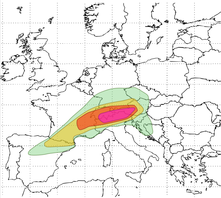
General Thunderstorms (Green)
Probability: 5–15% chance of lightning within 45 km.
Meaning: Isolated to scattered thunderstorms are expected.
Severe weather is not the primary concern, but isolated stronger cells may produce gusty winds or small hail.
Advice: Monitor updates, especially if traveling or working outdoors. Not classified as a severe risk area.
SLGT – Slight Risk (Yellow Orange)
Probability of severe weather within 45 km: ≥10%
Meaning: Organized thunderstorms are likely, and some may become severe.
This includes isolated instances of:
Damaging wind gusts
Marginally large hail (typically 2–4 cm in diameter)
Brief tornadoes
Localized flash flooding
Advice: Stay weather-aware. Events may be localized but impactful. Not all locations within the area will be affected.
MDT – Moderate Risk (Red)
Probability of severe weather within 45 km: ≥20%
Meaning: A higher confidence exists in a concentrated area of intense thunderstorms, with a risk for:
Widespread damaging winds
Large to very large hail (≥4 cm)
Isolated but possibly strong tornadoes
Flash flooding from slow-moving or training cells
Advice: Preparedness actions are recommended. Impacts could be widespread. These setups are often associated with robust synoptic or mesoscale forcing and high CAPE/shear environments.
HIGH – High Risk (Neon Pink)
Probability of severe weather within 45 km: >30%
Meaning: This level is reserved for high-confidence, high-impact convective outbreaks, such as:
Derecho events (long-lived, damaging windstorms)
Tornado outbreaks, possibly involving strong or long-track tornadoes
Very large to giant hail (≥8 cm)
Widespread flooding due to excessive rainfall
Advice: Take protective action immediately if warnings are issued. These events are rare but pose serious threats to life and property.
How to Interpret the Percentages
Each category refers to the statistical chance that at least one severe weather event will occur within 45 km of any given point inside the outlined area. This is not a percentage of area coverage but a point-probability used for risk communication.
Example:
A “20% (MDT)” probability means there is a 20% chance that a location within the shaded zone will experience at least one severe weather event (e.g., hail, wind, or tornado) within a 45 km radius during the forecast period (24h).